


The Waters we have in Common
I am sitting on the 7th floor at Niagara, Malmö university’s tallest building in the city’s former dockland area. From my northern-facing window I can see Universitetsholmen “the University pier” spread out below, merging in the west with the neighbourhood of Västra Hamnen “the Western harbour”. Further afield I glimpse the bay of Lomma. I glimpse the sea. The sea gives me a daily indication of the weather outside the airconditioned confines of the university. Depending on the time of day and season, it shifts from ash grey to powder blue to deep green, from choppy and frothy white to still and bright as a mirror. It is a continuous reminder of an ever-changing present and it also reminds me that the neighbourhoods below – long before they became Malmö’s designated hub of “knowledge” and post-industrial redevelopment, and long before they were the beating heart of the city’s blue-collar industries – they used to be water. They used to be sea.
That the ground that I am writing on is human-made and that the original shoreline went around where the street of Norra Vallgatan now runs, has got me thinking about water in its various historical and present forms in Malmö: Its role in shaping the infrastructure of the city, its role in citizens’ leisure activities, its role as home to other-than-human beings. And what happens when these roles change or go against certain human desires of urban expansion and redevelopment. What changes when the water disappears or loses its function? What happens when the water bodies that we – humans and other-than-human beings alike – have shared in common no longer exist? The city holds these former and present iterations of water commons within its very structure, only to become known when there is a disturbance to this structure: when a pipe bursts, a square is remade, or a heavy rainfall overwhelms the street gutters and storm drains. In a city founded on lakes, sand, and sea, water always makes its return in one form or another (Malmö Stad 1, 2024).
This reminder is not confined to the city itself, “the history of [the wider region of] Scania”, journalist Gabriella Håkansson notes, “was originally written in water” (2023). In fact, until the mid-1700s, the region was defined by wetlands and lakes rather than the fertile dryland that most contemporary Swedes associate Scania, Sweden’s breadbasket, with (Grundström, 2021). Yet, the water is there, just below the surface – some times metaphorically, other times literally. Today, if you walk around Malmö, you occasionally notice stickers and posters on lampposts and facades calling for the “restoration of wetlands”. They have been distributed by the organisation Återställ Våtmarker (n.d.), which campaigns with an environmental ethos to have water bodies reintroduced to drained Swedish landscapes. Foregrounded by the climate crisis of the Anthropocene, water, both as a benign force of (environmental) good and a fickle power of (material) destruction, figures heavily in current debates. And with sea levels rising and the city taking increased action against future flooding (Malmö Stad 2), another question lingers in my mind where I am sitting high up in the university tower: What if, or rather when, this city becomes water again?
Hydrocommons and the City
I am by no stretch the only one having felt the pull of such existential questions. There is a wealth of blue humanities scholarship that deal with these and many other “watery” questions. In thinking about water bodies as both shared physical elements and actual spaces in the city, I am particularly drawn to the way feminist cultural theorist Astrida Neimanis (2009) thinks about water as a more-than-human commons. For Neimanis (2009: 174), “a commons implies not only common use of a resource, but also common responsibility. […] Hence, the notion of a water commons concerns not only the management of the water supply that comes from our wells or taps or other localized delivery systems, but also common decision-making on the best use of geophysical bodies of water that we may not need for our personal use.”
Neimanis calls this the “hydrocommons”, positioning it as a reconfiguration of rights to, and of, water. Not excluding the right of all humans to fresh and clean water, the hydrocommons nevertheless introduces a less anthropocentric approach to Malmö’s water bodies. It expands the notion of what water is and does, including rather than separating humanity from a planetary whole. In Neimanis words our human “bodies of water open up to and intertwine with the bodies of water with whom we share this planet – those bodies in which we bathe, from which we drink, into which we excrete, which grace our gardens and constitute our multitudinous companion species.” (2009:162-63) Again, as the climate crisis grows in intensity and the pendulum of hydro-excess (floods, sky falls) and hydro-lack (draughts) is turning more and more extreme, embracing the water we have in common presents itself as a viable avenue of action to a very uncertain future. It brings us to ask: how do we connect and live with the hydrocommons, in theory as well as in practice?
Cerulean Hauntings: Tracing the Ghosts of Malmö’s Lost Waters
Environmental educator Nicolas Keller and I posed a similar question when we decided to organise a public workshop in May 2023. “Where”, we asked ourselves, “can we find, make, or restore Malmö’s blue commons?” The workshop formed part of the Locally Alien festival, itself an offshoot of Malmö’s yearly, international design festival Southern Swedish Design Days. The brainchild of Feral Malmö – a group focusing on how to improve the relationship between humans and Neimani’s (via Donna Haraway) “multitudinous companion species” in the city – the Locally Alien festival aimed to broadly emphasise “ecological culture” in Malmö. Nicolas and my proposal to the festival was to initiate a collective, critical mapping exercise of blue (or hydro) commons through using historical maps and photographs to trace the (dis)appearance of various public waterways and bodies in Malmö. These could be both human-made and “naturally” occurring, both historical and prospective.
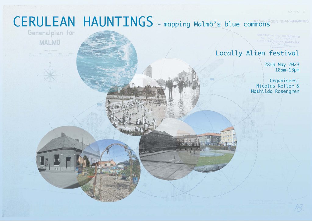
By creating a “Blue commons” map that covered both past, present, and future commons, we wanted to reflect on the shifting socio-ecological statuses of these bodies of water across both urban planning practices as well as everyday utilisations of urban space. “What,” we asked, “can the sea being turned into harbour grounds, wetlands being drained and built upon, public swimming pools being paved over, public fountains beings disused, and so forth, tell us about our past, present, and potential future relationship with the more-than-human waterscapes of Malmö?” Chartering these tangible, yet many times ephemeral, blue commons, we wanted the workshop to speak to the broader thematic of the Locally Alien festival: to bring socio-ecological “blue” ontologies and relations of humans and other-than-human beings to the fore through the temporal layering generated by the creative mapping practice. This, admittedly, sounded good on paper but how would we actually perform it in reality? Nicolas came up with the name of the workshop, “Cerulean hauntings”, and this provided the leitmotif of how to practically approach the structure of the workshop: how to map the ghosts of a commons that no longer, or not yet, exist.
As the month of May approached, we worked on how to make thoughts and ideas around blue commons accessible to a non-specialised audience. On top of the historical maps and photographs that we sourced from the digital archives of the Swedish Land Survey (Lantmäteriet), The City of Malmö, and the National Archives (Riksarkivet), this involved experimenting with “blue” soundscapes and diving deep into Malmö City Archive’s collection of old newspaper clips that in various ways concerned the water bodies in the city. In the end, we settled on a workshop structure that involved an outdoor activity at the beginning of the day followed by a collective mapping exercise. As an entry point into thinking with blue commons, we planned the outdoors activity as a walk around the neighbourhoods of Möllevången and Sofielund, which both houses several now-disappeared blue commons. The idea was to allow the participants to explore the squares, corners, and green spaces where there had previously existed blue commons, looking for the ghostly traces of water, without telling them too much about the commons in advance of this exploration. To their help each participant would receive a map with QR-codes corresponding to each spot we would visit. Each QR-code would lead to a 5-minute-long water soundscape that would give an indication of what kind of water body had existed there in the past. When the five minutes were up, we would congregate together as a group, we would listen to the participants’ guesses and reflections, and then Nicolas and I would tell them a bit about the water commons in question. With this exercise we really wanted to encourage the participants to think with the urban water and especially consider what kind of human-water relationships were present in the city, and how this had and might in the future affect both everyday experiences and urban planning practices. We wanted them to reflect on what we may lose when we lose a blue commons.
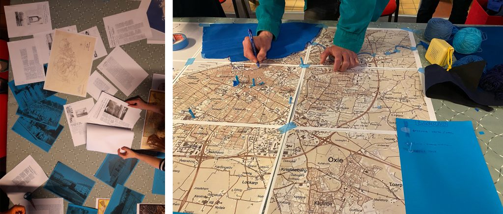
If the first part of the workshop predominantly would deal with loss – of commons, of water, of relations – we wanted the second part of the workshop to take these losses of historically situated commons and channel them into a map that would also project the present and future of a “blue Malmö”. STPLN, the cultural space and co-working hub in Västra Hamnen where the Locally Alien festival was taking place, was the ideal venue for this exercise. Not simply because they could provide us with a broad variety of blue material (yarn, crêpe paper, felt, cardboard and so on) to practically create the map but also from a metaphorical and conceptual point of view: as mentioned earlier, there was a time when Västra Hamnen used to be water. During the workshop, this fact that, barely two centuries ago, the neighbourhood used to be sea triggered discussions among the participants about the persistence of the water we have in common (set to return in the future as the sea level rises), the fragile existence of human-made urban landscapes, and the benefits of letting historical commons inform the future of Malmö. Such discussions were exactly what Nicolas and I wanted to encourage with the collective mapping exercise. We were careful not to be too prescriptive in how the exercise would evolve, instead, as inspiration, we provided the participants with a large, current map of Malmö, various “blue” materials, and a pile of printouts of historical newspaper clips and maps of past water bodies as well as future sea level rise projections of Malmö. The idea was to then let the participants take the lead. As the mapping would be a balancing act between historical renderings of water and climate-fiction narratives of the future, we wanted to encourage a low-bar, liberal interpretation of what a blue commons was, is, and could be. We wanted the exercise to broaden the way in which the participants viewed the water, the commons, and the city itself. For the mapping to raise more questions rather than answers by ultimately asking: what do we gain from making space for these commons and other watery relationships in Malmö?
From Theory to Practice: Collectively Mapping Malmö’s Blue Commons
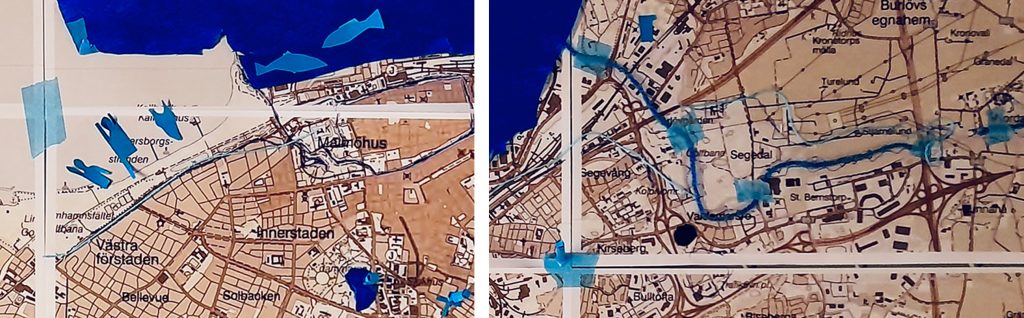
The actual workshop fell on a particularly warm and sunny spring day and the response we received from those who had signed up for the walk and the mapping exercise far exceeded our expectations. The participants – coming from a wide range of backgrounds but clearly all sharing a common interest in urban ecology, planning, and design practices – understood the workshop outline and were engaged from the very first “ghostly” water commons of our morning walk. Nicolas and I had settled on three specific locations for the walk: Nobeltorget, Sövervärn’s water tower and Naturmolnet. First, we visited the now paved-over fountain at Nobeltorget, where the participants walked around the square whilst listening to a soundscape of cascades of water splashing on stone and in shallow water pools. After the 5-minute soundtrack had finished, we gathered where the old fountain used to be. We collected impressions from the participants of how they imagined this particular water commons and then told them a bit about its history, showing archival photos of the fountain in its various iterations before it “disappeared” for good. What we collectively established was that the fountain must have been a welcome break to an otherwise heavily trafficked part of town – the sound of the bubbling water providing a contrast and slight respite to the noise of the fast-moving cars and buses around it, acting as a reminder of the urban ecologies that predominantly grey cityscapes might otherwise overlook. What we could also glean from the photos was that the fountain had not only fulfilled a decorative purpose but had been appropriated by local humans as a paddling pool during the summer months.
This realisation provided an excellent segue to our next water commons, the old paddling pool next to Södervärn’s water tower, only a quick 10-minute south-westerly walk from Nobeltorget. Here we followed the same procedure of first encouraging personal impressions of the past commons to then gather as a collective to talk about said commons. Now a fenced-in sport’s court, we showed how the paddling pool had long been a much-appreciated addition to the urban space. It had been mentioned on various occasions in local newspapers over the past century, with accompanying photos showing droves of children splashing happily in the water and the surrounding lawn being packed with people tanning or picnicking in the sun. In its heydays, this blue commons had been the nicknamed “Söderhavet” (the old Swedish name of the South Pacific) supposedly as a nod to both the neighbourhood’s name Södervärn and the water encountered there. Several of the participant had found testament to the local appreciation of this former water commons in the plaque that someone had erected next to the sport’s court, which stated that this is where the paddling pool Söderhavet used to be. The day we visited, despite the balmy weekend weather, the place was close to desolate, like a forgotten part of the neighbourhood. Looking at the archival photos, we pondered how differently the place must have felt when it was jammed packed with adults and children congregating in and around the water. How the water itself, at least during the warmer months, had provided a node of commonality between local city dwellers.
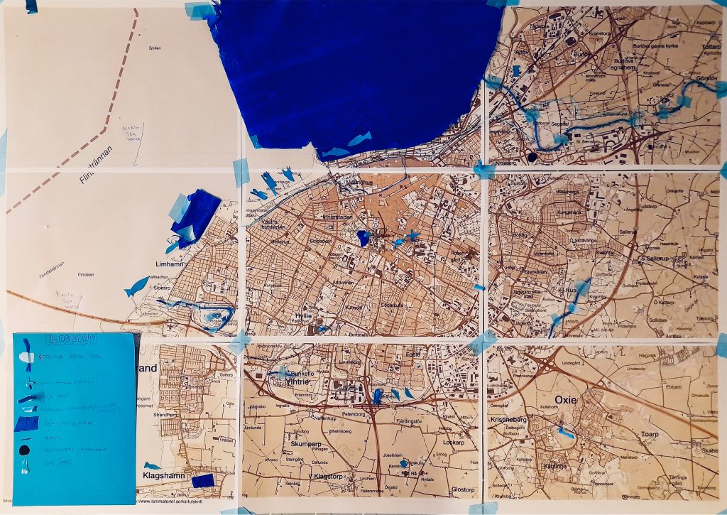
Still discussing how water commons may make or tie together a collective sense of urban belonging, we headed to our final outdoors location, Naturmolnet. A mere five minutes’ walk away, Naturmolnet used to be a small, boarded-up wasteland plot that the NGO Växtvärket (that Nicolas also worked for) had made into a community green space and garden. The plot had been abandoned for about 25 years, after the house standing on it had burnt down and thus there were the sounds of past domestic infrastructures (flushing toilets, running taps) that the participants encountered when they listened to the provided soundtrack. By the end of the recording, these sounds receded to make space for the noise of smattering rain. This, we revealed to the participants as we gathered by the outdoors seating area, we had added as a nod to the present and near-future state of the space. For, Nicolas explained to the group, Växtvärket had not only planned Naturmolnet as a community space, they had also used greening strategies on the site to experiment with possible sky fall mitigation pathways that could absorb future extreme rain falls and avoid disastrous flooding (such as the one Malmö experienced in August 2014, which had completely overwhelmed the grey infrastructural network (Hernebring et al 2015). As such, the visit to Naturmolnet provided a conceptual bridge between the historical blue commons of the first part of the workshop and the collective mapping exercise of the second part. Sitting on the communal benches in the shade from the glaring midday sunlight, we collectively tried to imagine an occasionally wetter future and how urban commons like Naturmolnet could offer green-blue solutions to such conditions. Then the whole group travelled together to STPLN, where we spent the next couple of hours exploring ways to make visible the trajectories and tensions between old, new, and future water bodies in the city. The material result was a patchwork of blue commons (paddling pools, fountains, water towers, sea etc.) dotted all over the city; of water pathways stretching through the urban landscape (old streams and disappeared rivers being brought to the surface by blue yarn); of future seascapes taking over (exemplified in bright blue paper); and of human and other-than-human dwellers’ fluid relationships with this landscape. A critical, speculative, yet also historically grounded idea of a blue Malmö.
The Waters we have in Common: a Conclusion
To conclude, the workshop provided Nicolas and I with an opportunity to explore what Neimanis’ hydrocommons could look like in practice, the collective walk and mapping exercises with an engaged public shining diverse and novel light on the many waters we – humans and other-than-humans alike – share in the city. For the participants, the workshop connected the idea of a blue Malmö in equal measures to the past, present, and future of the city and, hopefully by the end, left them with a sense of how their own human “bodies of water open up to and intertwine with the bodies of water” with whom they share urban space (Neimanis 2009: 162). Finally, for me, the fluidity of the many water bodies we encountered, discussed, and made visible together emphasised the simultaneously slippery, eclectic, and essential nature of the urban commons as a whole. Both a material entity in the urban landscape and a practice – a way of appropriating, sharing, and being – the workshop drove home the necessity of these pockets of commonality in the city. And that, in a time of climate crisis, we would all do best to learn to appreciate the social, cultural, ecological, and future values of the waters we all have in common.
Acknowledgement
The author would like to thank Nicolas Keller and all the participants of the Cerulean Hauntings workshop. Photographs by Mathilda Rosengren och Nicholas Keller.
The research was supported by Formas, under number 2019-01923
Note
A previous version of this article first appeared as a book chapter in the anthology Allmänningar och Stråk: Att göra Gemensamma rum. (2025) Eds. Karin Grundström, Mathilda Rosengren, and Edith Grundström.
References
Grundström, K. (2021) “Pratpromenad om spår av våtmarker” in Allmänningar och stråk: essäer, reflektion och pratpromenader Om gemensamma rum. Grundström, K. & Rosengren, M. (eds.) Malmö: Allmänningar och Stråk A&S, 71-82.
Hernebring, C., Milotti, S., Steen Kronborg, S., Wolf, T. & Mårtensson, E. (2015) ”Skyfallet i sydvästra Skåne 2014-08-31. Fokuserat mot konsekvenser och relation till regnstatistik i Malmö”, VATTEN – Journal of Water Management and Research 71: 85–99.
Håkansson, G. (2023) ”Skånes historia skrevs med vatten, inte raps” [newspaper article], Sydsvenskan 01.01.2023. https://www.sydsvenskan.se/2023-01-01/skanes-historia-skrevs-med-vatten-inte-raps (online version)
Malmö Stad 1 (2024) ”Stadens historia: Stadens ursprung” [web page] https://malmo.se/Uppleva-och-gora/Arkitektur-och-kulturarv/Malmos-historia/Stadens-historia/Stadens-ursprung.html (last visited 6 May 2024)
Malmö Stad 2 (2024) ”Klimatanpassning: Skyfallsanpassning” [web page] https://malmo.se/Stadsutveckling/Sa-utvecklar-vi-staden/Klimatanpassning/Skyfallsanpassning.html (last visited 6 May 2024)
Återställ Våtmarker (n.d.) ”Om oss” [web page] https://xn--terstllvtmarker-4kblj.se/om-oss/ (last visited 6 May 2024)
Maps and Digital Archives
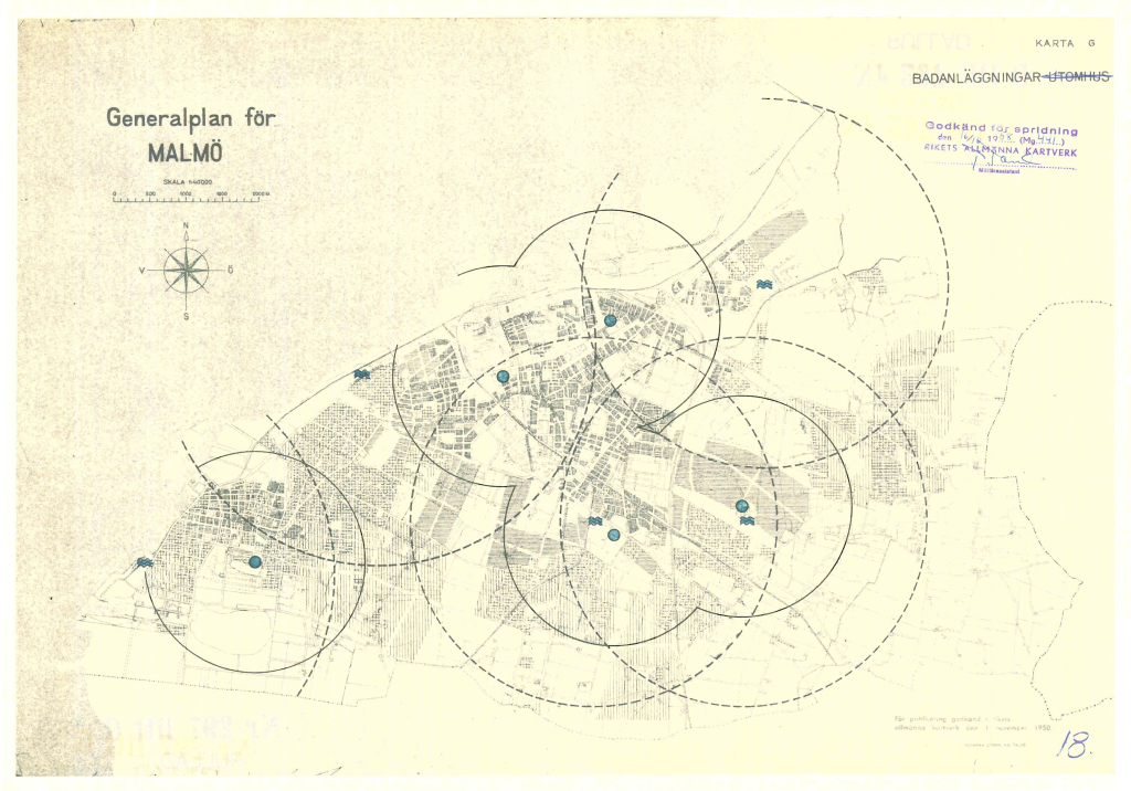
Malmö 297 G12 (1958). Generalplan för Malmö 1955-1970, 1:40 000. Stadsingenjörskontoret.
The collective map is based on an excerpt from Google maps.
Biography
Mathilda Rosengren is a researcher at the department of Urban studies, Malmö university. Rosengren is a visual anthropologist and urban geographer with a research focus on environmental and more-than-human ethnographies of cities and urban life in the Anthropocene. Her work takes inspiration from social and cultural anthropology, geography, multispecies ethnography, urban political ecology, landscape studies, and the environmental humanities.
Nicolas Keller is an environmental educator at Växtvärket, Malmö.